Randonnée Marche La Ferrière - Combe du Pélu - Photo
 Lindoli
Lindoli

Utilisateur

© OpenStreetMap contributors
Longueur
Longueur
5,6 km
Altitude max
Altitude max
1122 m
Dénivelé positif
Dénivelé positif
142 m
Km-Effort
Km-Effort  
7,5 km
Altitude min
Altitude min
999 m
Dénivelé négatif
Dénivelé négatif
143 m
Boucle
Boucle
Oui
Date de création :
2018-04-17 17:46:57.701
Dernière modification :
2018-04-17 17:46:57.701

(0 Avis)

Marche
Marche
1h17
Difficulté : Facile

Scannez ce code QR pour ouvrir la randonnée dans l'application SityTrail

Application GPS de randonnée GRATUITE

Logo SityTrail SityTrail

IGN / Instituts géographiques

Télécharger SityTrail sur l'App Store Télécharger SityTrail sur Google Play

Logo SityTrail SityTrail World

Le monde est à vous

Télécharger SityTrail sur l'App Store Télécharger SityTrail sur Google Play Télécharger SityTrail sur Huawei AppGallery

À propos

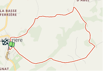
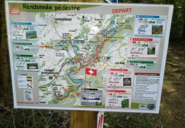
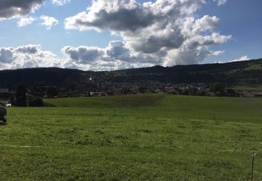
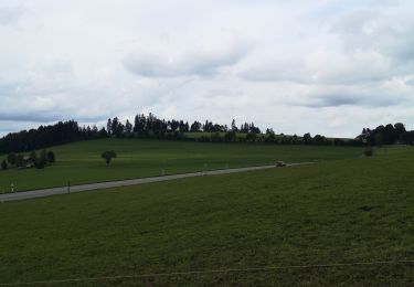
Randonnée Marche de 5,6 km à découvrir à Berne, Arrondissement administratif du Jura bernois, La Ferrière. Cette randonnée est proposée par Lindoli.

Profil altimétrique

Localisation

Pays :
Suisse
Région :
Berne
Département/Province :
Arrondissement administratif du Jura bernois
Commune :
La Ferrière
Localité :
Unknown
Départ:(Dec)
Départ:(UTM)
340195 ; 5222911 (32T) N.

Randonnées à proximité

Randonnée A pied Renan (BE) - Renan Le Plan-Pertuis - Photo
A pied
GUIDE+

A pied

Facile
Renan (BE), Berne, Arrondissement administratif du Jura bernois, Suisse
4,2 km | 7,6 km-effort
1h 42min
Non
Randonnée Marche Fournet-Blancheroche - Combe de Biaufond - Photo
Marche
fredfred

Marche

Moyen
(1)
Fournet-Blancheroche, Bourgogne-Franche-Comté, Doubs, France
11,7 km | 18,3 km-effort
4h 17min
Non
Randonnée Marche Charquemont - LES ECHELLES DE LA MORT - Photo
Marche
walrou63

Marche

Difficile
Charquemont, Bourgogne-Franche-Comté, Doubs, France
10,4 km | 17,1 km-effort
4h 42min
Oui
Randonnée Marche Charquemont - boucle autour des échelles de la mort - Photo
Marche
fab0202

Marche

Moyen
Charquemont, Bourgogne-Franche-Comté, Doubs, France
8,8 km | 15 km-effort
2h 22min
Oui
Randonnée Marche Fournet-Blancheroche - Fournet Blancheroche Le Refrain (IBP87) 22 avril 2021 CAF - Photo
Marche
TRIMAILLE

Marche

Difficile
Fournet-Blancheroche, Bourgogne-Franche-Comté, Doubs, France
22 km | 34 km-effort
6h 20min
Oui
Randonnée Marche Fournet-Blancheroche - Barrage du Refrain (IBP 88) 01 avril 2021 reco Pierre R - Photo
Marche
TRIMAILLE

Marche

Difficile
Fournet-Blancheroche, Bourgogne-Franche-Comté, Doubs, France
21 km | 33 km-effort
7h 11min
Oui
Randonnée Autre activité Fournet-Blancheroche - GTJ étape 1  - Photo
Autre activité
Manu0105

Autre activité

Facile
Fournet-Blancheroche, Bourgogne-Franche-Comté, Doubs, France
39 km | 50 km-effort
3h 41min
Non
Randonnée Marche Fournet-Blancheroche - Les échelles de la mort ( par Fournet Blancheroche et Biaufond - Photo
Marche
patoche21

Marche

Très difficile
Fournet-Blancheroche, Bourgogne-Franche-Comté, Doubs, France
15,1 km | 23 km-effort
5h 18min
Oui
Randonnée Marche La Chaux-de-Fonds - la cibourg - Photo
Marche
suzanne.bron

Marche

Facile
La Chaux-de-Fonds, Neuchâtel, Inconnu, Suisse
3,8 km | 5,2 km-effort
1h 21min
Non


Fermer
Mes abonnements